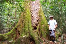
TREE DETAILS

[Click to Enlarge]
Additional Information
View Interesting Information
View Website Link
View Additional Website Link
|
Common Name : |
MacKay Cedar, Acacia Cedar, Red Siris |
|
Scientific Name : |
Paraserianthes toona |
|
Circumference : |
7.70 metres (303 inches) |
|
Height : |
41.00 metres (134 feet) |
|
Crown : |
23.00 metres (75 feet) |
|
Points : |
456 |
|
State : |
QLDN |
|
Town : |
Cairns, Barron Gorge NP |
|
Access : |
Public |
|
Location : |
Walking track near Stoney Creek |
|
Coordinates : |
16° 52' 41.42" s 145° 39' 42.98" e Click to view in maps |
|
|
|
|
Nominator : |
Craig Harriss |
|
Year Measured : |
2020 |
|
Age : |
125 |
|
Type : |
Remnant |
|
Comments : |
NATIONAL CHAMPION A couple of large shelf fungi on butt. I have managed to find Airborne Laser Scanning of the Stoney Creek area and have analysed the canopy height and ground elevation from the point cloud. I knew this data existed because it was my area of employment but I have now retired. The Lidar was aquired for the Qld Govt so its quality is good with nominated accuracy of 0.33 metres elevation. The data was classified and the difference in maximum canopy height and ground elevation at the location of the Mackay Cedar is 41m or more. The Mackay Cedar has very fine leaves so the reflections of the canopy might be from small branches/twigs at the outer edge of the canopy. VIEW INTERESTING INFORMATION LINK |
Scroll left to right for more photos.... Click on a photo to enlarge it